By TruthWave Investigative Desk
Introduction: Why This Investigation Matters Now
For nearly three decades, environmental protection in India followed a settled constitutional principle: a forest is defined by its ecological character, not by paperwork or technical labels.
(Primary source: Supreme Court of India judgments database – https://main.sci.gov.in/judgments)
That principle weakened in late 2024–2025.
During continuing forest-conservation proceedings under the long-running Godavarman cases, the Supreme Court of India provisionally accepted a technical definition submitted by the Ministry of Environment, Forest and Climate Change (MoEF&CC).
(Source: Supreme Court orders & proceedings – https://main.sci.gov.in/orders)
Under this definition, an “Aravalli hill” is recognised only if it rises 100 metres or more above local relief.
(Source: MoEF&CC notifications – https://moef.gov.in/en/notifications/)
This was not a final constitutional ruling.
But in environmental governance, temporary definitions often decide permanent outcomes on the ground.
This TruthWave investigation explains how a numerical threshold, framed as administrative clarity, has become a structural climate risk for North India’s water, air, and future resilience.
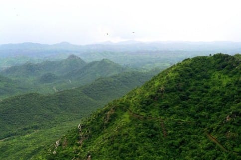
What the Aravalli Hills Really Are: A Climate System, Not Isolated Peaks
The Aravalli Hills stretch across Gujarat, Rajasthan, Haryana, and Delhi, forming one of the world’s oldest mountain systems.
(Source: Geological Survey of India – https://www.gsi.gov.in/)
Their relevance today is not historical pride—it is functional survival infrastructure.
The Aravallis act as a barrier against desertification from the Thar Desert.
(Source: UNCCD India profile – https://www.unccd.int/)
They serve as groundwater recharge zones for Delhi-NCR by allowing rainwater to percolate through fractured quartzite rock.
(Source: Central Ground Water Board – https://cgwb.gov.in/)
They reduce dust storms, heatwaves, and air-quality stress in north-western India.
(Source: MoEF&CC climate adaptation documents – https://moef.gov.in/)
These functions depend on continuous low-rise ridges, not only on tall hills.
The Legal Bedrock: Godavarman vs Union of India (1996)
All modern forest protection flows from one landmark case:
Case: T.N. Godavarman Thirumulpad vs. Union of India
Petition: WP (Civil) No. 202 of 1995
(Source: Supreme Court case records – https://main.sci.gov.in/case-status)
In this judgment, the Supreme Court ruled that the word “forest” must be understood according to its dictionary meaning, regardless of ownership, revenue records, or administrative labels.
(Source: Supreme Court judgments – https://main.sci.gov.in/judgments)
This interpretation extended the Forest (Conservation) Act, 1980 to all ecologically forested land.
(Source: Forest (Conservation) Act – https://legislative.gov.in/)
For decades, this doctrine protected the Aravalli Range as a system, not as individual land parcels.
What Changed in 2024–2025: From Ecology to Elevation
During ongoing hearings linked to the continuing Godavarman matters, the Supreme Court provisionally accepted a definition proposed by MoEF&CC for administrative uniformity.
(Source: Supreme Court interim orders – https://main.sci.gov.in/orders)
The definition states:
- Aravalli Hill: landform with ≥100 metres local relief
- Aravalli Range: two or more such hills within 500 metres
(Source: MoEF&CC submissions – https://moef.gov.in/en/notifications/)
The Court did not declare this definition final or binding nationwide.
However, provisional acceptance allows states to apply it immediately while granting or denying mining and land-use permissions.
In environmental law, classification often determines survival.
Why the 100-Metre Rule Is a Scientific Blind Spot
Groundwater systems do not respond to elevation charts.
Recharge depends on sub-surface rock fractures, joints, and soil permeability, not hill height.
(Source: CGWB hydrogeological manuals – https://cgwb.gov.in/)
Many Aravalli ridges measuring 40–80 metres act as primary aquifer recharge mouths for Delhi-NCR.
(Source: CGWB Aquifer Mapping Programme – https://cgwb.gov.in/AQM)
Mining such ridges permanently seals underground water pathways, a loss no later court order can reverse.
(Source: CGWB groundwater impact assessments – https://cgwb.gov.in/)
Visual Explainer: Why Hill Height Is Irrelevant to Groundwater
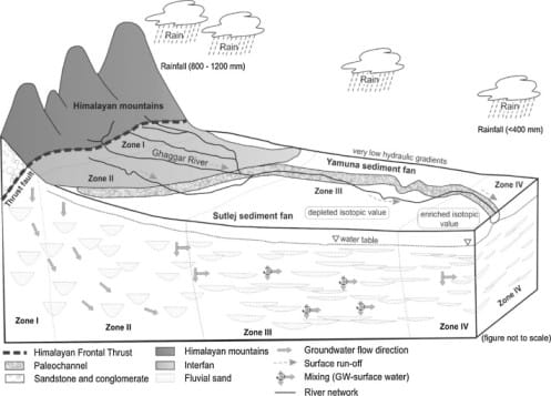
What this shows:
Low-rise Aravalli ridges function as fractured-rock sponges, feeding aquifers horizontally beneath cities.
TruthWave Finding:
A ridge can fail a height test yet still sustain millions.
The Supreme Court’s Own Warning: CEC Report No. 3 (2024)
The Central Empowered Committee (CEC)—appointed by the Supreme Court—issued Report No. 3 of 2024.
(Source: Official CEC page – https://main.sci.gov.in/committee/cec)
The report warned that mining reaching groundwater levels must be stopped to prevent irreversible aquifer destruction.
(Source: CEC Report No. 3/2024 – https://main.sci.gov.in/committee/cec)
This warning directly contradicts height-based protection logic.
The Legal Pressure Point: Punjab Land Preservation Act (PLPA)
In Haryana, Aravalli protection operates largely through the Punjab Land Preservation Act, 1900, especially Section 4.
(Source: Bare Act – https://legislative.gov.in/sites/default/files/A1900-02.pdf)
Section 4 allows land-use restrictions to be imposed, modified, or allowed to lapse via notification.
Once land is reclassified as “not a hill,” protections weaken automatically.
This is how definition becomes erasure.
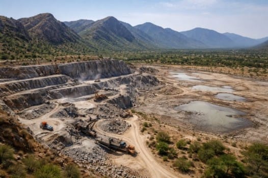
Satellite Evidence: Hills That Have Already Disappeared
This risk is not hypothetical.
The Wildlife Institute of India (WII) has documented extensive degradation across the Aravalli system.
(Source: WII publications – https://wii.gov.in/)
ISRO’s Space Applications Centre (SAC) reports that 25–31 hills in Rajasthan’s Aravalli belt are no longer visible due to mining and land conversion.
(Source: ISRO Desertification & Land Degradation Atlas – https://sac.gov.in/Vyom/DesertificationAtlas)
Satellite Proof: Seeing Is Believing
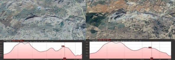
🛰️ TruthWave Tool: Verify It Yourself
- Visit https://bhuvan.nrsc.gov.in/
- Select Thematic Services
- Choose Land Degradation / Desertification
- Enter your district (Rajasthan, Haryana, NCR)
TruthWave does not ask for blind trust—it gives readers the tools to verify.
Mangar Bani–Badkhal Belt: Where Policy Meets People
Around Mangar Bani and the Badkhal Lake catchment, groundwater has fallen from ~80 feet to nearly 300 feet in one generation.
(Source: CGWB district reports – https://cgwb.gov.in/)
Seasonal streams have vanished, and dust-storm intensity affecting Delhi-NCR has increased.
(Source: MoEF&CC air & climate data – https://moef.gov.in/)
This is not protest—it is hydrology responding to land loss.
The Delhi-NCR Water Clock
CGWB classifies large parts of Gurugram and Faridabad as “over-exploited” groundwater zones.
(Source: CGWB assessments – https://cgwb.gov.in/)
These zones overlap with low-rise Aravalli recharge ridges now vulnerable under the 100-metre rule.
Remove the ridges, and urban water scarcity accelerates silently.
Global Accountability: UN Commitments
India is a signatory to the United Nations Convention to Combat Desertification
(Source: https://www.unccd.int/)
India is also a party to the United Nations Framework Convention on Climate Change
(Source: https://unfccc.int/)
Under the Bonn Challenge, India pledged to restore 26 million hectares of degraded land by 2030.
(Source: https://www.bonnchallenge.org/commitments/india)
Reclassifying ecosystems out of protection while promising restoration creates a measurable credibility gap.
Conclusion: Erased by Definition
The Supreme Court has not ordered the destruction of the Aravalli Hills.
(Source: Supreme Court orders – https://main.sci.gov.in/orders)
But by provisionally accepting a height-based definition, it has exposed a regulatory blind spot that policy can exploit faster than law can correct.
Ecology does not follow geometry.
Aquifers do not respect elevation charts.
If definitions harden into precedent, the Aravallis will not collapse loudly.
They will disappear file by file.
For a detailed explanation of howWhy Indian Cities Are Running Out of Water — Explained for India and the World TruthWave : https://truthwave.in/indian-cities-water-crisis-explained/
“I appreciate that TruthWave provides a space to discuss these issues without fear. There is a lot more to the [specific topic, e.g., ‘water distribution’] in my district that remains off the record. Glad to see this platform gaining traction.”